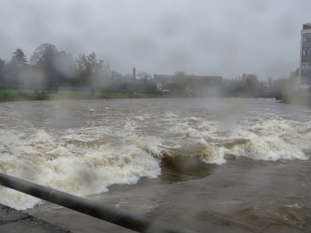
My new book, Cumbrian Contrasts, highlights the source of a river as the source of life: the Derwent, the Duddon, the Kent and the Eden. In December 2015 the Paris conference on Climate Change coincided with relentless rainfall and floods across Cumbria- the destructive force of rivers causing havoc. Carlisle feels the full force of the River Eden. I wrote about the floods of February 2004 in About Scout Scar. Then there was 2009.
November 2009. A dismal, wet November with the ground already saturated when weather forecasters announced the imminence of an Extreme Weather Event - a category rarely designated. It would last from Tuesday 17 through Thursday 19.
Atlantic lows dominated, with a south-westerly wind blowing along the front and keeping it stuck over Cumbria. Currents of warm, moisture-laden air came in from the Azores and, blocked by the Cumbrian fells, rose rapidly, cooled, and then came precipitation. Orographic enhancement of rainfall: a standing wave. It rained and rained and rained over Cumbria.
As front after front piled in, the central fells experienced unprecedented rainfall. Rain fell relentlessly from 8.00pm on Wednesday until 5.00 am on Friday morning, when there was a brief respite. On the fells, winds were storm-force with gusts of over 100 mph, severe even at low levels. During 24 hours, 372 mm of rainfall was recorded by the rain-gauge at Seathwaite Farm: the highest ever. Off Scafell Pike and Great End, off Great Gable, off Glaramara and the Borrowdale Fells, cascading down becks and gills, seeking out adventitious channels, pouring straight off the fell-side, gushing down, a colossal volume of water overwhelming the network of becks that feed the large river system of the Derwent -one of the fastest flowing rivers in the country- by Seathwaite and Seatoller, by Rosthwaite and Grange-in-Borrowdale, through Derwentwater to meet the heavily-swollen River Greta gathering water off Blencathra and bursting its banks and causing flooding in Keswick, on through Bassenthwaite fed by becks off Skiddaw, laden with debris and battering bridges, heading for Cockermouth and its confluence with the River Cocker where the speed of the disaster was shocking to people living in Main Street who saw deep water racing by, and on to Workington where Northside Bridge had become unstable and in the darkness of 4.00 am PC Bill Barker, trying to direct traffic away from the bridge, was swept to his death as it collapsed. Swept down-stream to the Irish Sea, his body was discovered fifteen miles away on a beach at Allonby.
Thursday 19 November was a dark day. A dark day for people living in Bridge Street, Burneside, where the River Kent burst its banks and flooded their houses. Darkness hung over Kendal, abiding darkness, and rain fell relentlessly with the river at its most dangerous during that afternoon and late into the night. Only fifteen miles long, the Kent is a fast-flowing river and by mid-morning on Friday it had retreated within its bounds and along the Kendal riverside traces of debris showed where it had been, with sandbags piled in gateways and doorways. Here water had come up through floors and flooded cellars.
Boats sank on Windermere and the River Leven burst its banks. Water poured through Ambleside with waterfalls cascading onto the road and masonry toppling.
A beck behind the Glenridding Hotel burst its banks and flood water swept through the ground floor. Lake levels on Ullswater were higher than anyone remembered, with water some 6-8 inches over the pier. By the early hours of Friday morning the waters issuing from Ullswater struck Eamont Bridge and homes were flooded. This extreme weather event showed the distinctive character of catchments. The River Eden is of slower flood-response time than the Derwent and, strengthened after the floods of January 2005, the Carlisle defences held.
At Cockermouth, the RAF sent in Sea King helicopters to rescue people, some through the roofs of flooded houses, and the RNLI evacuated people from Main Street. Lorton Bridge and the Southwaite foot bridge collapsed. All over the county the Mountain Rescue Services were ferrying police, doctors and social services to where they were needed: with ordinary vehicles unable to cope with the floods.
The rescue phase was concentrated on Thursday 19: the culmination of the extreme weather event. But there was scant respite, and a severe weather event with heavy rains and gale force winds was predicted for Tuesday 24 November: parts of the fells could collect up to 100 mm of rain, putting swollen rivers and beleaguered bridges under sustained pressure.
On Friday 20 there were engineers up and down the River Kent assessing the state of bridges being pummelled by a fast-flowing and dangerous river laden with debris. Army engineers helped check bridges and protect abandoned homes in Cockermouth. At Workington, Northside Bridge and a footbridge had gone and the Calva Bridge was unstable. Rivers were too high, too dangerous, to assess possible structural damage below the water-line. The emergency services were trying to move into recovery mode whilst under threat of the next severe weather event.
How do weathermen prepare us for what is to come? Tomasz Shafenaker mentioned the orographic emphasis, then declined to go further –‘ enough of physics.’
Tuesday 24. A severe weather warning : 24 hours of persistent rain. 100mm on fells. SW winds with gusts up to 70 mph.’ Soggy weather.’
Wednesday 25. ‘Towering shower clouds, with hail. A squally, rattling front.’
Thursday 26 .’ Wind driven rain. From continuous rain to frequent showers:’
2009 saw the wettest November on record, with Cumbria recording the highest rainfall ever in 24 hours. The flood-hit towns are located along the course of the River Derwent on its journey to the Irish Sea. The river is designated a Site of Special Scientific Interest: Atlantic salmon breed in the Derwent which supports three kinds of lamprey. During autumn the salmon run would be on, with eggs laid in the river bed- a river swollen and contaminated with debris hurtling downstream. Record high water levels in becks and lakes would result in loss of reeds, with consequent losses to sea trout and brown trout. It would take time to assess the impact of the November floods on the ecology of Cumbrian river systems.
The colossal power of water erosion caused landslips and landslides, with rivers rerouting, severe damage to river banks, boulders and rocks pounding and scouring river beds and dumped in fields along with millions of tons of gravel and silt. Some farmers had neither the man-power nor the resources to reclaim pastures that provide them with hay and silage – essential fodder for livestock. And there are evident tensions: farmers may be reluctant to lose productive land whilst an Environment Agency priority is to restore natural floodplains. ‘ Meandering rivers and functioning flood plains can hold water on the land, keeping it out of homes in times of flood.’ Thus ‘Future Water’, the government’s water strategy for England.
There is a history of flooding in the catchment of the River Derwent but, with climate change , intensity and frequency of rainfall is predicted to become more severe. How to put in place a response that is sustainable and effective? It’s a complex question and it is possible that no defence programme would entirely protect against an extreme weather event of such magnitude.
 RSS Feed